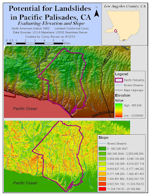
Digital Elevation Models (DEMs) are commonly used in GIS to provide elevation data and permit spatial analyses for specific geographic areas. Within a GIS, spatial analyses can be conducted to calculate slope, aspect, and hill shade of a DEM in order to greater understand the terrain surface as it relates to elevation. In GIS, slope refers to the rate of change of elevation at a surface location, while aspect is concerned with the directional measure of the slope, and lastly, hill shade involves modeling the appearance of the terrain by evaluating the relationship between sunlight and surface features. The focus of this lab was to utilize a DEM to evaluate the potential risk of landslides occurring in Pacific Palisades, CA. The DEM, with its hill shade and slope, was analyzed in order to better understand the terrain surface of Pacific Palisades and evaluate the risk of landslides occurring relative to surrounding areas in Los Angeles.
In order to conduct the spatial analysis for Pacific Palisades, a DEM of the area as well as surrounding areas was downloaded from the USGS Seamless Server with 1/3 arc second resolution. The Pacific Palisades boundary was found within the Los Angeles County subdivision data that was attained from the UCLA Mapshare website. A hill shade was calculated and set with a 50% transparency behind the original DEM to show a more realistic model of the terrain surface. Additionally, slope was calculated to evaluate the dramatic changes in elevation for Pacific Palisades relative to surrounding Los Angeles areas. Lastly, data on major highways and streams and rivers were added to provide referential information of the area.
Landslides are more likely to occur in areas with a steep slope, unstable soil, high moisture content, and exposure to erosion by wave action (http://nsgd.gso.uri.edu/scu/scug73002.pdf). According to the DEM, hill shade, and slope models, the Pacific Palisades area has a high elevation with a high slope relative to the surrounding Los Angeles area. Additionally, the area contains many streams and rivers resulting in greater soil instability and thus, greater susceptibility to landslides. Close proximity to the Pacific Ocean results in exposure to wave erosion which increases the risk for landslides. While these factors do not directly cause a landslide, they contribute to the gradual accumulation of stress on the land. When a disturbance such as excessive rainfall or an earthquake occurs, the already weakened terrain surface falls along with the houses and other urban development atop. In Pacific Palisades, over 50 landslides have occurred despite efforts to reinforce the unstable soil of the bluffs (http://nsgd.gso.uri.edu/scu/scug73002.pdf). Despite the high risk to landslides, houses continue to be built and bought at high prices by individuals valuing the aesthetic value of living in Pacific Palisades. A better alternative might be to encourage greater housing development concentrated in either lower-lying cities, such as Santa Monica, or further inland areas, such as Brentwood. Diminishing the number of houses and people living on land highly susceptible to landslides will ultimately result in less damage and injuries when landslides occur.
Digital Elevation Models along with spatial analyses are important tools that allow for an assessment of surface terrain to greater understand issues such as landslide susceptibility. By cartographically displaying elevation data, places can be assessed relative to surrounding areas and solutions can be generated before disturbances and potential disasters occur. Ultimately, planning ahead and taking preventative measures are the best ways to ensure safety and prevent massive damage when landslides occur. Utilizing DEMs and evaluating their slope and hill shade provides knowledge of the terrain surface that enhances the planning and preparation to mitigate the overall damage caused by landslides or other natural catastrophes.
No comments:
Post a Comment