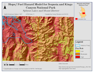
Assessing fire hazards in fire prone areas is vital for fire management and prevention. Two principle factors influencing wildland fire susceptibility include slope and vegetation type, which acts as fuel for fires. Additionally, weather patterns will also influence the risk of fire. Areas with steeper slopes will cause more rapid spread upslope due to the proximity of the flame to overhead fuel. Vegetation types that are highly prone to acting as fuels for fires include shrublands and hardwoods. Lastly, hot and dry weather acting with winds can act as the igniting force to start wild fires. In the Sequoia and Kings Canyon National Park, fire is an essential component for the regeneration of many plant species as well as for maintaining the livelihoods of native animals (http://www.nps.gov/archive/seki/fire/indxfire.htm). Suppression of fire in this area has led to the accumulation of debris resulting in intense, widespread fires. In order to prevent massive fires and sustain the fire-dependent ecosystems, prescribed fires have been used within the area. Evaluating the slope and surface fuels within this region allows for an assessment of the overall risk of fire and ultimately provides a model for future wild fire management.
The study site for the slope/ fuel hazard incorporated two 7.5 minute quadrangles, Sphynx Lakes and Mount Brewer, within the Sequoia and Kings Canyon National Park. The slope was calculated for the study site and reclassified using the NFPA Model 1144 standards. This model was created by the National Fire Protection Agency to evaluate the relationship between slope and fuel and their effect on fire risk within an area According to this model, slope was classified based on NFPA hazard points: 1, 4, 7, 8, and 10. These corresponded, respectively, with minimum-maximum percent slope categories: 0-10, 10-20, 20-30, 30-40, and 40-999.The vegetation types for study site included white fir mixed conifer forest, lodgepole pine forest, barren rock with sparse vegetation, red fir forest, montane chaparral, subalpine conifer forest, meadow, other (mostly water bodies), ponderosa- mixed conifer forest, and xeric conifer forest. Similar to the slope reclassification, the vegetation types were assigned a fuel class along with the associated NFPA hazard points based on the NFPA Model 1144. The classes within this model include non fuel, light, medium, heavy, and slash, and correlate, respectively, with the hazard points 0, 5, 10, 20, and 25. The reclassification of the study site vegetation types included other as a non fuel (0), meadow and barren rock with sparse vegetation as light fuels (5), xeric conifer forest as medium (10), and all other forests as well as montane chaparral as heavy fuels (20). After reclassifying the slope and fuel types, the values were added to create the slope/ fuel hazard model. Areas with lower values (0-9) have a low burn hazard whereas areas with slightly higher values (10-19) have a moderate burn hazard and areas with the highest values (20-30) have a high burn hazard value.
In addition to evaluating slope and fuel, historic fires within the region were also displayed. By evaluating the model, it is evident that historic fires have occurred in areas with a high risk to fire. Understanding the factors behind wildfires as well as the location of past fires in the region allows for better planning of prescribed fires as well as prevention of large-scale wild fires.
Although it would be easier to display a vegetation map and a slope map, combining the two data sets by creating a slope/fuel hazard model allows for an evaluation of how the two factors interact and influence fire burn hazards in a region. By utilizing spatial analysis within GIS, models can be generated to display how environmental factors react and their impact on natural occurrences such as wild fires.

No comments:
Post a Comment