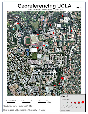
Georeferencing is an important tool that registers a map into a GIS system by applying real world coordinates. By georeferencing a map image, the map image is assigned a specific location and spatial analyses can be performed. One method to attain the real world coordinates is to utilize a GPS system which measures the coordinates based on satellite signals. Although GPS is valuable in providing coordinates, often times it is not entirely accurate due to inherent errors, user errors, and discrepancies that arise when interacting with a GIS. Overall, it is important to evaluate these uncertainties in order to minimize their effects on the georeferencing to allow for greater accuracy.
Despite its worldwide use in a variety of fields, GPS remains a relatively recent development. As a result, signal clarity and reception have not been able to be modified to produce entirely accurate results. For example, other electronic signals or structures such as walls and windows can block GPS signals and generate imprecise coordinates for a location. Additionally, limited reception in an area would result in greater difficulty for the GPS to accurately give a location’s coordinates. Another source of error when using GPS results from its use by a user. Not allowing sufficient time for the GPS to register the location as well as not remembering the exact location where the coordinates were taken ultimately results in inaccuracies. In this lab, much of the error was human-induced due to the inability to locate exactly where the coordinates were taken on a map. In order to minimize this error, it is important to use ground control points (GCP) on corners of buildings, landmarks, or easily identifiable objects that will be easy to precisely locate on a map image. Lastly, errors arise through the interaction between the GPS and GIS. Regardless of the accuracy of the GPS coordinates, matching the locations of the GCP points on the maps with the coordinates will inevitably produce some errors as it is highly unlikely that the precise location on the map will be located. In this lab, the orthophoto used was not updated and did not have a high resolution which presented some uncertainty when choosing the location where the GCP points were taken. Additionally, the points were taken by different groups who did not always report the precise the location where the coordinates were taken.
The results of these errors were represented by the GIS as residuals which provide the difference between the entered coordinates and the fitted coordinates relative to the other GCP points. Additionally, the GIS generated an RMS (root, mean, square) score which provides a measure of the overall error within the ground control points of the georeferenced map. For this lab, the georeferenced image generated an RMS of 3.39415. Some GCP points were removed when georeferencing the map due to their extremely high residual values which greatly increased the RMS. Although it is better to have a lower RMS score, ultimately human and GPS errors have generated a higher RMS value. Most of the uncertainty is likely attributed to the fact that the GCP points were collected by different groups and therefore, the exact locations of where the coordinates were taken had to be estimated on the map. Overall, I would improve the georeferencing of this image by taking the GCP points myself and in areas, such as corners of buildings, which are clearly visible and discernable on the map. Additionally, I would include ground control check points in order to check to see that my GCP points and current georeferencing were accurate.
Georeferencing is a valuable tool that allows virtually any map to be registered in space using real world coordinates. By continuing to develop greater technologies to improve GPS as well as other locational devices, greater accuracy can be attained when performing spatial analyses in GIS. Ultimately, the easiest way to minimize error within georeferencing is to control for human-induced error and be as precise as possible when measuring GCP points as well as finding the location of the GCP points on the map.
No comments:
Post a Comment